Maps
Maps
- Product
- Qty in Cart
- Quantity
- Price
- Subtotal
-

Captain Segull's Nearshore: St George River, ME to Penobscot Bay and River Waterproof Chart
$19.99Catch more fish with Captain Segull’s® Charts, designed for the serious sport fisherman.This chart provides detail of the bays from St George River, ME to Penobscot Bay and River. It includes GPS coordinates, wrecks, reefs, shoals, fishing areas,...- SKU:
- 100703499
- short-description:
- PENOBSCOT BAY INSHORE
- optionTitle:
- PBR61
$19.99 -

Captain Segull's Nearshore: St George River, ME to Porstmouth, NH Waterproof Chart
$19.99Catch more fish with Captain Segull’s® Charts, designed for the serious sport fisherman.This chart provides detail of the bays from St. George River, ME to Portsmouth Harbor, NH. It includes GPS coordinates, wrecks, reefs, shoals, fishing areas,...- SKU:
- 100703497
- short-description:
- PORTSMOUTH NH TO ST GEORGE RIVER MAINE
- optionTitle:
- GEP60
$19.99 -

DeLorme Maine Fishing Depth Map
$39.95Great for beginners and experts alike, the DeLorme® Maine Fishing Depth Map includes more than 1,700 fishing maps across 16 Maine counties! Whether you already know which types of fish you want to go for or you're simply curious, detailed stocking...- SKU:
- 100629928
- short-description:
- MAINE FISHING AND DEPTH MAPS
- optionTitle:
- 010-13219-00
$39.95 -

Maptech Decorative Nautical Chart - Portland Harbor ME
$44.95Display your favorite harbor in your home or office! Just peel the backing off and apply directly to your wall, door, window, or any smooth surface. It's easy to peel off and reapply, is low tack, and does not leave any residue. Displays Portland Maine...- SKU:
- 100018300
- short-description:
- DECORATIVE NAUTICAL PORTLAND ME
- optionTitle:
- D-PORME
$44.95 -

Captain Segull's Small Boat / Kayak: Saco Bay, ME Sportfishing Chart
$11.99Captain Segull's Small Boat / Kayak Charts highlight latitude and longitude (GPS), Loran lines, contour lines, shore services such as fuel docks, loading ramps, kayak launches, pump-out stations and restaurants. Also shown are fishing holes with local...- SKU:
- 100000647
- short-description:
- SACO BAY ME
- optionTitle:
- SC0387
$11.99 -

Captain Segull's Small Boat / Kayak: Portland, ME Sportfishing Chart
$11.99Captain Segull's Small Boat / Kayak Charts highlight latitude and longitude (GPS), Loran lines, contour lines, shore services such as fuel docks, loading ramps, kayak launches, pump-out stations and restaurants. Also shown are fishing holes with local...- SKU:
- 100000646
- short-description:
- PORTLAND ME
- optionTitle:
- PTL388
$11.99 -

Maptech Folding Waterproof Chart - Merrimack River and Plum Island Sound
$29.95Maptech's® flip-fold charts are printed on a tough waterproof paper that will not tear when the wind hits it as you look for the next spot to fish. No matter how good your electronics are, viewing a large area in detail is best done with a chart. Prudent...- SKU:
- 1008580
- short-description:
- MERRIMCK RIVER PLUM ISLAND SOUND
- optionTitle:
- WPC083
$29.95 -

Maptech Folding Waterproof Chart - Massachusetts Bay and Boston Harbor
$29.95Maptech's® flip-fold charts are printed on a tough waterproof paper that will not tear when the wind hits it as you look for the next spot to fish. No matter how good your electronics are, viewing a large area in detail is best done with a chart. Prudent...- SKU:
- 1008576
- short-description:
- MASS BAY BOSTON HARBOR
- optionTitle:
- WPC021
$29.95 -
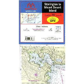
Maptech Stonington to Mount Desert Island Waterproof Chart
$29.95This chart covers the myriad islands, harbors, and passages from Eggemoggin Reach and Eastern Penobscot Bay to Bar Harbor. Maptech® waterproof charts are a big improvement over large, cumbersome charts. Spread a chart out to its full width, or keep it...- SKU:
- 95708
- short-description:
- STONINGTON TO MT DESERT WP CHART
- optionTitle:
- WPC075
$29.95 -

Maptech Waterproof Chartbook - Cape Cod Canal to Casco Bay, Maine
$69.95This compact chartbook is ideal for day-sailors, fishing boats and trailer boats. It's made of waterproof, tear-resistant synthetic paper that withstands the elements. Covers Cape Cod Canal to Casco Bay, Maine Also includes Outer Cape to Nauset...- SKU:
- 67572
- short-description:
- WATERPROOF CHARTBK CAPE COD TO CAPE AN
- optionTitle:
- 245
$69.95 -

Northern Forest Canoe Trail #11: Moosehead / Penobscot Region - Moosehead Lake to Umbazooksus Stream
$12.95The 740-mile water trail links the watersheds of northern New York, Vermont, Quebec, New Hampshire, and Maine, following Native American travel routes through the rivers of this region. Moosehead Lake is largest lake in Maine-Thoreau traveled this...- SKU:
- 68617
- short-description:
- NO.FRST CANOE TRL MOOSEHEAD SEC.11
- optionTitle:
- 994-3
$12.95 -

Northern Forest Canoe Trail #10: Greater Jackman: Maine - Spencer Stream to Moosehead Lake
$12.95The 740-mile water trail links the watersheds of northern New York, Vermont, Quebec, New Hampshire, and Maine, following Native American travel routes through the rivers of this region. Paddle the Spencer Stream watershed and the Moose River. Offers...- SKU:
- 68615
- short-description:
- NO.FRST CANOE TRAIL GRTR JCKMN SEC.10
- optionTitle:
- 993-5
$12.95 -

Northern Forest Canoe Trail #9: Flagstaff Lake Region: Maine - Rangeley Lake to Spencer Stream
$12.95The 740-mile water trail links the watersheds of northern New York, Vermont, Quebec, New Hampshire, and Maine, following Native American travel routes through the rivers of this region. This section of the trail follows the Dead River, with the shallow...- SKU:
- 68614
- short-description:
- NO.FRST CANOE TRL FLAGSTAFF LA SEC.9
- optionTitle:
- 992-7
$12.95 -

National Geographic Allagsh Wilderness Waterway South Map
$14.95The front side of the Allagash Wilderness Waterway South map details from the southern portion of Eagle Lake to the northwestern edge of Baxter State Park and the northern reaches of Chesuncook Lake. It includes Allagash Lake, Chamberlain Lake,...- SKU:
- 62927
- short-description:
- ALLAGASH WILDERNESS WATERWAY SOUTH
- optionTitle:
- 401
$14.95 -

National Geographic Allagash Wilderness Waterway North Map
$14.95The Allagash Wilderness Waterway is a majestic 92-mile-long ribbon of rivers, lakes, ponds, and streams that winds its way through the heart of the North Maine Woods. National Geographic's Trails Illustrated map of Allagash Wilderness Waterway North is...- SKU:
- 62926
- short-description:
- ALLAGASH WILDERNESS WATERWAY NORTH3
- optionTitle:
- 400
$14.95 -

Captain Segull's Small Boat / Kayak: Merrimack River, Plum Island Sound, Massachusetts Nautical Sportfishing Chart
$11.99Captain Segull's Small Boat / Kayak Charts highlight latitude and longitude (GPS), Loran lines, contour lines, shore services such as fuel docks, loading ramps, kayak launches, pump-out stations and restaurants. Also shown are fishing holes with local...- SKU:
- 62914
- short-description:
- MERRIMACK RIVER
- optionTitle:
- MER304
$11.99 -

Northern Forest Canoe Trail #4: Islands and Farms: Vermont - Lake Champlain to Missisquoi River
$12.95The 740-mile water trail links the watersheds of northern New York, Vermont, Quebec, New Hampshire, and Maine, following Native American travel routes through the rivers of this region. This section of the Northern Forest Canoe Trail crosses the famous...- SKU:
- 55075
- short-description:
- NO.FRST CANOE TRL ISLANDS+FARM SEC.4
- optionTitle:
- 996-X
$12.95 -

Northern Forest Canoe Trail #2: Adirondack North Country, Central: New York - Long Lake to Saranac River
$12.95The 740-mile water trail links the watersheds of northern New York, Vermont, Quebec, New Hampshire, and Maine, following Native American travel routes through the rivers of this region. This map is nearly to the end of the Trail's western-most terminus...- SKU:
- 55072
- short-description:
- NO.FRST CANOE TRAIL ADIRONDK C. SEC 2
- optionTitle:
- 980-3
$12.95 -

Captain Segull's Offshore: Gulf of Maine, Massachusetts Bay Nautical Sportfishing Chart
$19.99Catch more fish with Captain Segull’s Charts, designed for the serious sport fisherman. A double sided chart, Side A shows the Gulf of Maine from Penobscot Bay to Boston, Massachusetts Bay and includes an inset of Portland Harbor, ME. Side B...- SKU:
- 55003
- short-description:
- GULF OF MAINE & MASS BAY OFFSHR CHART
- optionTitle:
- GMM17
$19.99 -

Captain Segull's Bathymetric Cape Ann to Jeffreys Ledge Nautical Sportfishing Chart
$19.99Catch more fish with Captain Segull’s Charts, designed for the serious sport fisherman. This double-sided chart displays a detailed chart color coded by depth on one side and a regular NOAA chart on the other side. It includes GPS coordinates,...- SKU:
- 55001
- short-description:
- CAPE ANN TO JEFFRY'S LEDGE BATHYMTR CH
- optionTitle:
- CA201
$19.99