Images

×


Promotions
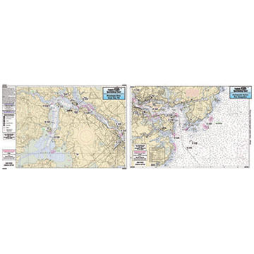
Captain Segull's Small Boat / Kayak: Portsmouth Harbor, NH and Great Bay Nautical Sportfishing Map
$11.99
Captain Segull's® Sport Fishing Charts cover the North American coastline from the Penobscot Bay, Maine south to Louisiana and Texas, including Bahamas and Cuba, and even into the Gulf of Mexico!
Captain Segull's Charts are designed for serious sport fishermen. They show you fishing spots that will help you catch fish. The charts highlight latitude and longitude, Loran lines, contour lines, shore services such as fuel docks, loading ramps, kayak launches, pump-out stations and restaurants. Also highlighted are fishing holes with local names, coordinates of buoys, inlets, reefs, rigs and wrecks.
If you want to know where to catch fish, get your own Captain Segull's Sport Fishing Chart!
| Description | Price | Qty |
|---|---|---|
GB306More Info |
$11.99 |